
Sacramento offers a surprisingly rich urban experience for visitors who choose to skip the rental car.
California's capital city has invested heavily in public transportation, bike infrastructure, and walkable neighborhoods that make car-free exploration both feasible and enjoyable.
Many travelers assume they need a vehicle to properly explore Sacramento, but this couldn't be further from the truth.
The city's compact downtown core, extensive light rail system, and growing network of bike lanes create opportunities to experience Sacramento's culture, dining scene, and attractions without the hassle of parking or traffic.
Getting around Sacramento without a car also allows you to experience the city more intimately.
You'll discover hidden gems tucked between buildings, strike up conversations with locals at bus stops, and move at a pace that lets you truly absorb the atmosphere of each neighborhood.
Here are eight practical tips to help you navigate Sacramento car-free while making the most of your visit.
1)) Master The Sacramento Regional Transit System
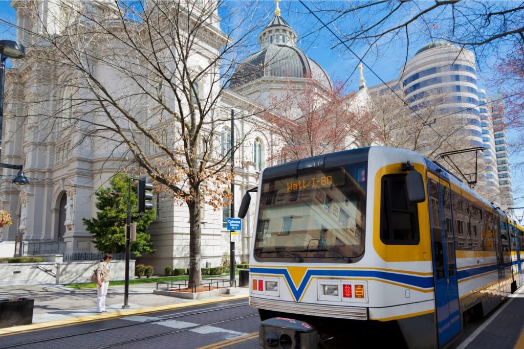
Sacramento Regional Transit (SacRT) operates an extensive network of buses and light rail lines that connect downtown Sacramento with surrounding neighborhoods and suburbs.
The system includes three light rail lines: the Blue Line running east-west, the Gold Line extending northeast, and the Green Line heading southeast.
Purchase a day pass for unlimited rides across all SacRT services. The mobile app makes buying tickets convenient and eliminates the need to carry exact change.
Light rail trains run approximately every 15 minutes during peak hours and every 30 minutes during off-peak times.
The Downtown Transit Mall on K Street serves as the central hub where multiple bus routes converge.
This makes transferring between different lines straightforward, and the covered stations provide shelter while you wait.
Plan your routes using the SacRT trip planner or Google Maps transit directions.
Both tools provide real-time arrival information and can suggest the fastest routes between destinations.
2)) Embrace Sacramento's Bike-Friendly Infrastructure
Sacramento consistently ranks among the most bike-friendly cities in America, with over 200 miles of bike lanes and paths.
The flat terrain throughout most of the city makes cycling accessible for riders of all fitness levels.
JUMP bikes, operated by Uber, provide convenient bike-sharing throughout downtown and midtown Sacramento.
These electric-assist bikes help you cover longer distances without breaking a sweat.
Download the Uber app to locate and unlock bikes near your location.
The American River Bike Trail extends for 32 miles along the American River, offering a scenic route that connects downtown Sacramento with Folsom.
Even if you don't ride the entire trail, shorter segments provide beautiful views and a peaceful escape from city streets.
Always wear a helmet and follow traffic laws when cycling in Sacramento.
The city requires helmets for riders under 18, but wearing one regardless of age significantly improves your safety.
3)) Focus On Walkable Neighborhoods
Sacramento's grid system makes navigation on foot straightforward, and several neighborhoods offer concentrated attractions within walking distance.
Downtown Sacramento spans roughly 20 blocks, making it entirely walkable for most visitors.
Midtown Sacramento, bounded roughly by 16th Street to the east and the Capitol to the west, contains the highest concentration of restaurants, bars, and shops.
This area rewards exploration on foot, with many businesses located in converted historic buildings along tree-lined streets.
The R Street Corridor has transformed from an industrial area into a hip district filled with breweries, restaurants, and entertainment venues.
The entire corridor stretches for about eight blocks, perfect for a leisurely afternoon stroll.
Old Sacramento's wooden sidewalks and 19th-century buildings transport you back to Gold Rush days.
This 28-acre historic district sits right along the Sacramento River and can be thoroughly explored in a few hours on foot.
4)) Take Advantage Of Rideshare And Taxi Services
Uber and Lyft operate throughout Sacramento with good availability, especially in downtown and midtown areas.
Both services typically provide rides within 5-10 minutes of booking during normal hours.
Traditional taxi companies like Yellow Cab Sacramento still operate in the city and can be useful for trips to areas with limited rideshare coverage.
Some taxi companies accept reservations, which can be helpful for early morning airport transfers.
Consider ridesharing for longer distances or when traveling with luggage.
The cost often compares favorably to multiple transit fares, especially when splitting among several people.
Sacramento's relatively compact size means most rideshare trips within the central city cost between $8-15, making this option budget-friendly for occasional use.
5)) Plan Your Route Around Key Transit Hubs
The Sacramento Valley Station serves as the city's main train depot, with Amtrak connections to the Bay Area, Los Angeles, and other California destinations.
The station also connects to several bus routes, making it an excellent starting point for car-free exploration.
Sacramento International Airport connects to downtown via the SacRT Route 42 bus, which runs every 30 minutes.
The trip takes approximately 45 minutes and costs significantly less than taxi or rideshare options.
The State Capitol building area serves as another major transit hub, with multiple bus routes stopping nearby.
Many Sacramento attractions cluster around the Capitol, including the State Railroad Museum and Capitol Park.
University of California Davis Medical Center area also functions as a transit hub, with light rail and bus connections.
This location provides access to the medical district and connects to routes heading toward UC Davis main campus.
6)) Use Sacramento's River Transportation
The Sacramento RiverTrain offers seasonal excursions along the Sacramento River, providing both transportation and entertainment.
While not a regular transit option, these themed trips offer unique perspectives of the Sacramento Valley.
Water taxi services operate during special events and festivals, connecting different points along the riverfront.
Check with the Old Sacramento Waterfront Association for current water transportation options.
The Sacramento River provides a scenic backdrop for many walking and cycling routes.
The River Walk Trail connects various riverfront attractions and can be combined with other transportation methods for longer journeys.
River-adjacent areas often feature the highest concentration of visitor attractions, making water-focused transportation options particularly valuable for tourists.
7)) Combine Transportation Methods Strategically
Mix different transportation modes to optimize your Sacramento experience.
Start your day with light rail to reach a distant neighborhood, explore on foot, then use rideshare to return to your accommodation.
Many Sacramento attractions cluster in specific areas, allowing you to use transit to reach a neighborhood and then explore multiple sites on foot.
This approach minimizes transportation costs while maximizing your time at attractions.
Consider renting a bike for half-day adventures, then switching to public transit when you're ready to move to a different part of the city. Most SacRT buses accommodate bikes on front-mounted racks.
Plan your most transit-dependent activities for weekdays when public transportation runs more frequently.
Save walkable neighborhoods and bike-friendly routes for weekends when transit schedules may be reduced.
8)) Download Essential Transportation Apps
The SacRT app provides real-time arrival information, trip planning, and mobile ticketing for all buses and light rail lines.
The app works offline for basic schedule information, useful when cell service is spotty.
Citymapper offers comprehensive Sacramento transit information, including walking directions, bike routes, and public transportation options.
The app compares different route options and provides accurate time estimates.
Google Maps transit directions work exceptionally well in Sacramento, often providing the most up-to-date route information by combining data from multiple transportation providers.
JUMP bikes require the Uber app for bike-sharing access.
The same app handles both rideshare and bike rental, simplifying your transportation toolkit.
Conclusion
Sacramento's commitment to alternative transportation makes car-free exploration not just possible, but genuinely enjoyable.
The city's relatively small scale means you can experience diverse neighborhoods, attractions, and dining options without spending excessive time in transit.
Start planning your car-free Sacramento adventure by identifying your must-see attractions, then mapping out transportation options between them.
Download the essential apps mentioned above, and consider purchasing transit passes in advance to streamline your experience.
Remember that Sacramento's dry climate and abundant sunshine make walking and cycling pleasant for most of the year.
Pack comfortable shoes, stay hydrated, and embrace the slower pace that comes with car-free travel.
Sacramento Apparel
Embrace the spirit of Sacramento with our high-quality, machine-washable apparel! Whether you're a local or just passing through, our Sacramento Apparel offers a variety of styles, from T-shirts and Tank Tops to Pullover Hoodies and V-neck t-shirts. Our clothing is a perfect way to remember your time in California's capital city or to gift a piece of the Sacramento experience to loved ones. They're made with durability in mind, ensuring that the memories can be worn and cherished for years to come. Explore our collection now and take home a piece of Sacramento pride today!